The Goat Rocks wilderness is one of my favorite parts of the Pacific Crest Trail in Washington. Scenic beauty abounds and there are dramatic rock faces everywhere. The area is also very accessible to day hikers who want to hike through mountain meadows and scramble up rocks for panoramic views of nearby volcanoes like Rainier and Adams.
Old Snowy is one of the highest peaks in the Goat Rocks and an easily followed spur trail leads up to its summit from the PCT. The approach hike is all on well graded trail with the last hundred meters being a non-technical scramble on loose rock. The views from the top and its relative accessibility makes it popular in summer, but it is just far enough away from the trailhead that I have never felt it was crowded.
However, inn poor weather, the views disappear and the upper regions start giving you the impression that you are in the realm of Emyn Muil. Quite lovely in its harsh way but definitely a bit dreary and inhospitable, especially when the rain starts lashing you up high. As always, check the weather and ensure you have your ten essentials with appropriate clothing for the conditions. On clear days, this trail is merely a little rocky. On poor days with bad weather, a twisted ankle near the summit of Old Snowy can be a life-threatening situation.
View of Goat Rocks from junction of Snowgrass Flats trail and PCT
Mt. Adams to the South on the PCT
REFERENCE/LINKS
- Snowgrass Trail #96 — US Forest Service
- Weather Forecast — weather.gov
MAPS
- Snowgrass Flats + Old Snowy — CalTopo
- Snowgrass Flats TH to Old Snowy map w/route (downloadable JPEG)
PERMITS
PARKING
A Northwest Forest Pass is not required at the Snowgrass Flats trailhead but it is required at the nearby Berry Patch trailhead. Some websites say there is a fee at Snowgrass Flats trailhead but the Forest Service website and my experience say otherwise.
Given the crowds on summer weekends, it may be easier to park at the Berry Patch trailhead and use the half-mile long connector trail. You can purchase a map and a forest pass at the Cowlitz Valley Ranger Station in Randall, which is about 13 miles before the Forest Road 21 junction.
WILDERNESS PERMIT
A free, self-issued wilderness permit is required and is available at the trailhead.
AVAILABILITY/SEASON
The Snowgrass Flats TH is at 4600' and will frequently be inaccessible in winter. Call the Ranger District at 360-497-1103 for information about conditions. Old Snowy tops out at 7285' and there are a couple semi-permanent snow fields, so expect snow year round.
Suggested: July to October for best conditions.
GETTING THERE
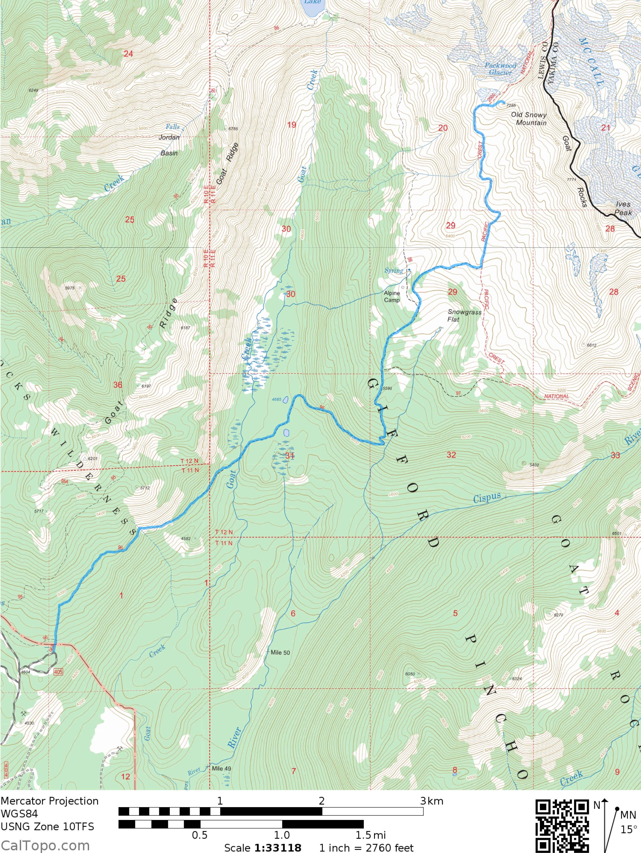
From I-5, travel east on Highway 12 about 62 miles to the junction with Forest Road 21, it will be on your right before Packwood. Turn right (south) onto Forest Road 21 and follow it uphill for about 13 miles until Forest Road 2150, signed “Chambers Lake”. Follow the signs another 2 miles to the Snowgrass Flats trailhead. (map)
Hawkeye Point, Goat Lake, and Mt. Rainier from ridge above Packwood Glacier
ROUTE DESCRIPTION
At the Snowgrass Flats TH, fill out your wilderness permit and then head up on Snowgrass Hiker Trail (#96A). In a short 0.1 miles, the connector trail from the Berry Patch Trailhead will join in from the left. Continue heading up on, what is now, Snowgrass Trail (#96).
Four miles from the trailhead you will reach the junction with Snowgrass By-pass Trail (#97), which goes right towards Cispus Basin. Continue going straight.
In another mile you will reach the beginning of the Snowgrass Flat area and another trail junction. To the left is a trail that goes to Goat Lake. There are a few side trails in this area that head to campsites and can be confusing. You want to continue on Snowgrass Trail (#96) and head up towards the Pacific Crest Trail.
In another mile, you will reach the junction with the Pacific Crest Trail. To the right (southwards) is the route to Cispus Basin, which is another beautiful area well worth a visit. You want to up and to the left (northwards) towards Old Snowy. In fair weather this is a glorious hike with views of Mt. Adams behind you, the Goat Rocks above to your right, and in a couple miles a truly spectacular view of Mt. Rainier.
Continue following the Pacific Crest Trail. The route becomes rockier and every so often you will see little campsites nestled between boulders or in flat area. In a little over a mile and a half, you will reach a semi-permanent snowfield that you will need to cross.
A little beyond this snowfield you will reach a ridge with a nice view overlooking the Packwood Glacier and a view of Goat Lake to the west. Head east, up the ridge, and you will soon find a trail junction. To the left the PCT continues by traversing along the side of Old Snowy. The trail to the right switchbacks up to the summit of Old Snowy. Go right.
In a half mile, there is a nice break spot at a trail junction where a large wall of rocks allows a bit of protection from wind and precipitation. To the left is the trail back down to the PCT. The summit trail now goes right (southeast) straight towards the summit and soon becomes more of a scramble than a hike. Nothing too technical but be mindful of where other hikers are located in case a rock comes loose.
The summit is rocky but has a number of places to sit and enjoy the view of the surrounding area. On a nice day, you will be able to see Mt. Rainier, Goat Lake, the Goat Rocks, and Mt. Adams. Definitely bring your camera.
Return the way you came.